Tim Edmonds, one of our Digi-Coaches based at Kapiti District Libraries, has given us a timely reminder that GPT doesn’t have all the answers to life, certainly when it comes to data analytics!
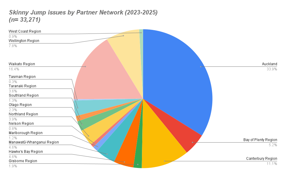
We have been trying to present our Jump stats by local and regional authority area, but have been struggling to find a look up table that groups NZ towns and cities into these regions. I thought this would be an excellent job for Chat GPT. Chat GPT helpfully identified StatsNZ as a source of data (something I sort of already knew), and directed me to some stats tables that might have been useful if I had the skills to navigate them, but after numerous frustrating attempts I failed to get the output I needed.
So with nearly 50 Digi-Coaches now working in libraries in Northland, Waikato, Central North Island, Wellington and the Top of the South Island, I threw out this challenge to them and Tim came up with the goods, in less than an hour, he said.
His solution was not to use Chat GPT, nor Claude, nor Gemini, nor Co-Pilot, but a proprietary tool called ArcGIS Pro, something he was familiar with as an Insights Data Analyst in a previous life.
So what are the results? Here’s a taster. Probably not a lot of surprises. We are planning to develop this a bit further – we are missing 10% of all issues in smaller towns and this also doesn’t include the online orders (another 10%). So with Tim’s help, we plan to add these to the pot and also do a sort by TLAs (Councils).